
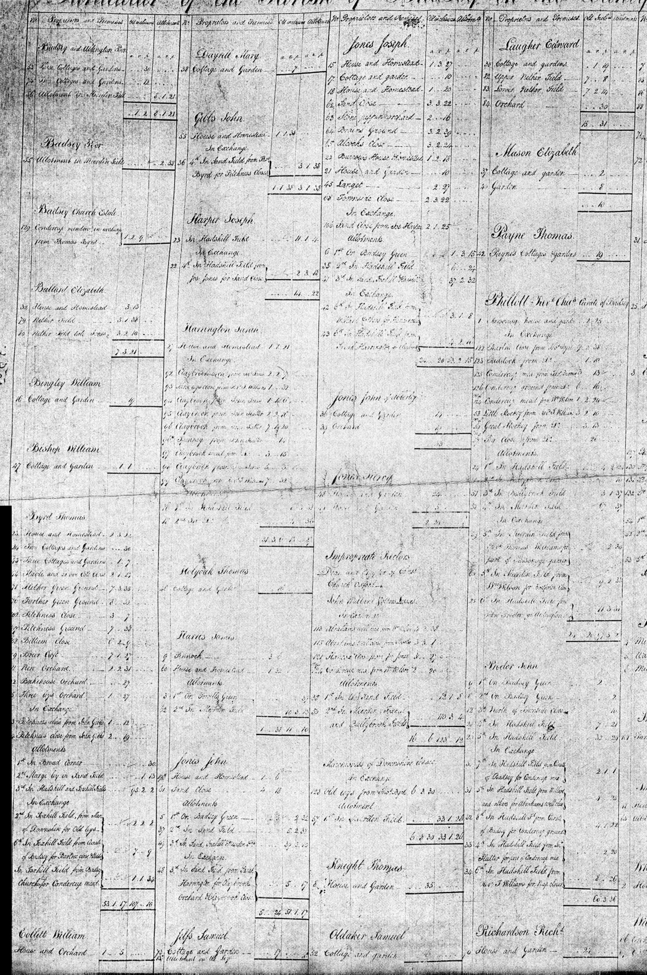
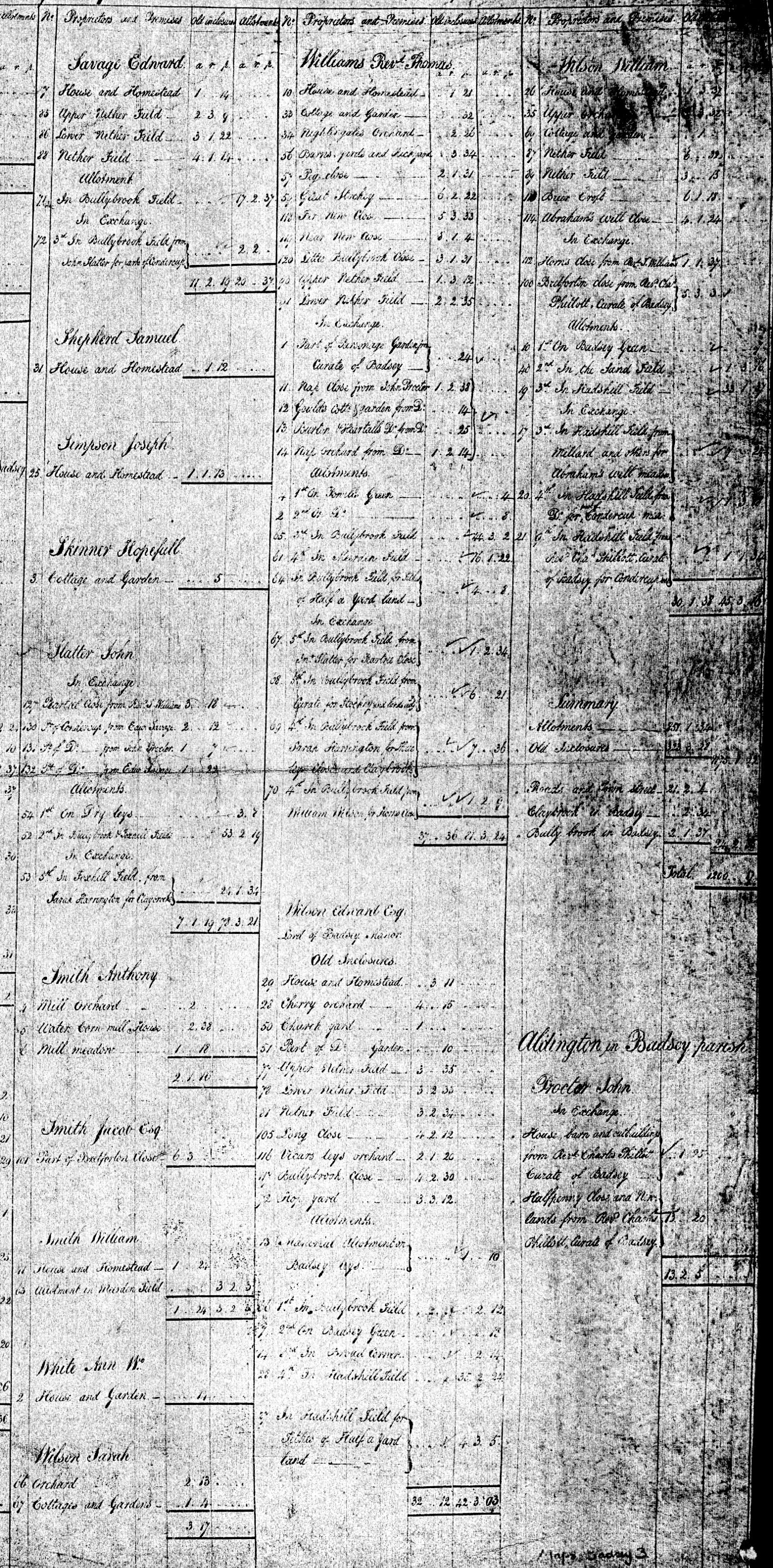
The 1812 enclosure map is the earliest known large scale map of Badsey. No tithe maps are known. Images of the map may be viewed here. There is also a complete transcription of the Badsey award schedules that accompany this map.
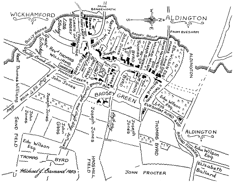
The map below has been adapted from the original. Note especially the main street turning east at the Manor House and continuing along what is now Old Post Office Lane and The Green footpath. The map was redrawn in 1983 by Michael J Barnard for A Brief History of Badsey and Aldington.
Here is a street map of the village today and details of other maps of Badsey and Aldington.
The original map is held in the library of Christ Church, Oxford. It measures 45 by 29 inches (114 by 74cm), is drawn at a scale of 1 inch to 4 chains and is coloured. The library reference is Badsey maps 2. There are two related documents, Badsey maps 1 and 3, which are not actually maps but detail the enclosure agreements with many names and properties mentioned.
The original map has more detail and covers a larger area than Michael Barnard's drawing shows. It extends to the border with Gloucestershire to the south and the border with Bretforton to the east, but it does not include Aldington which had its own enclosure act.
Recently we have located a second copy of the original map at the Worcestershire Record Office. It does not appear in their map index but is filed under enclosure papers. The reference is S497, BA 10879/561 (i -iii).
Here are some of the place names shown on the original map but not shown in the drawing above. There were several cases where the same name is given to more than one field e.g. there are three Condercup Meadows.
North side of the parish
Condercup Meadow - field bounded on the south by the Evesham to Bretforton road and on the east by the Bretforton boundary.
Claybrook, Claybrook Meadow.
Penland, Halfpenny Close - names just to the NW of the junction of the Aldington road with the Evesham to Bretforton road.
East side of parish
Foxhill Field - bounded by Sands Lane bridleway on the south side and the Bretforton boundary on the east side.
South side of parish
Bullybrook Field and Meerden Field - both names used twice for different fields adjoining Bully Brook.
Dry Leys - Going along the Willersey Road the last field on the left before crossing into to Gloucestershire.
Allens Gate - on the bridleway between Pear Tree Corner and Bretforton, on the border between Badsey and Bretforton parishes.
Condercup Meadow - fields on two sides of the Willersey Road near Bowers Hill.
Peartree Close - small field near Bowers Hill.
Abrahams Well - shown as inlet off the S side of Bully Brook north of Pear Tree Corner. Nearby field names are Abrahams Well Close and Abrahams Well Meadow.
Attached to the 1812 enclosure map are particulars of land and landowners. An extract from these can be downloaded as two large GIF files (1.3MB each) - left side and right side.