
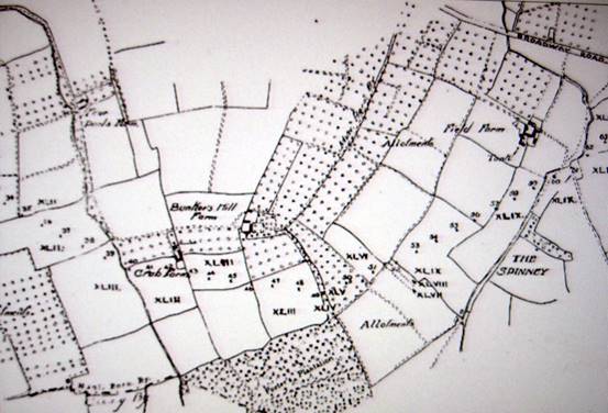
A map from 1927, showing the route of new electricity supply lines through Wickhamford, has marked on it, Bunkers Hill Farm. This lies just outside of the boundary of the village on the Bengeworth side of Longdon Hill.
A book by Anthony Poulton-Smith, Worcestershire Place-names (2003), has an interesting comment in the section on Wickhamford. He writes that there are innumerable examples of English place-names being transferred to the United States of America, but that examples of America place-names being transferred back to England are extremely rare. He gives Bunkers Hill in Wickhamford as one case in point. There are no records of this name prior to the Battle of Bunker Hill in 1775, one of the few British victories during the American War of Independence. He suggests that whosoever held land in the local area at this time may have had some connection with this British success and named the hill in honour of it. It is possible that someone locally had a relative involved in the battle or campaign.
It seems as if the occupant of the land on the Bengeworth side of the ridge, now called Longdon Hill (or London Hill on some early maps), decided to name their farm after the Battle of Bunker Hill and probably gave the same name to at least the western end of Longdon Hill straddling the Bengeworth/Wickhamford boundary.
The earliest reference found to the name 'Bunkers Hill Farm' is from 1828, when Thomas Pratt died and his livestock was put up for sale the following year. Pratt family members have been buried in the old Bengeworth churchyard since 1552, but how long they lived at Bunkers Hill is not known. Other families lived there in 1861 (William Collins, a carter) and 1881 (Charles Meadows, farmer and William Drinkwater, farm bailliff). In 1871 another Thomas Pratt was in residence. Meadows was farming 100 acres and Pratt 145 acres, so the extent of the farm could have been on both sides of the Bengeworth/Wickhamford boundary. By the late 1930s the farm buildings were in poor repair and it was abandoned and the building material used elsewhere.
The first Ordnance Survey map of the district in 1838, shows an access to Bunkers Hill Farm along the top of 'London' Hill from the turnpike road (the present A44) right on the Wickhamford parish boundary. ('Wyndy Ridge' is now accessed along this track.) However, the main access to the farm was via a track from Bengeworth.
Tom Locke - February 2019