
Land use in Badsey 1941
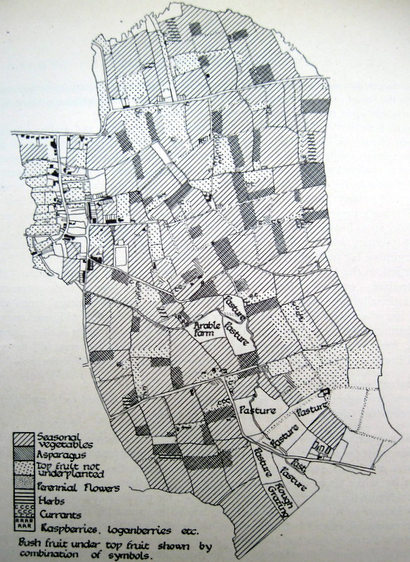
This 1941 map, produced by Ron Sidwell, showed the utilisation of land in Badsey. The National Farm Survey took place in the early years of the Second World War and questionnaires on land usage were sent to 231 growers with land in Badsey, 69 in Aldington and 142 in Wickhamford. Ron Sidwell described the map:
The importance of fruit is comparatively small in this area and there is a striking contrast between the open cultivation of this parish and the heavily fruited smallholdings of, for example, the Cleeve Hill area. Of the total area of approximately 1,000 acres under horticultural crops in the parish approximately 135 were under top fruit, 90 under asparagus, 14 acres under small fruit, 10 acres under herbs (chiefly sage and thyme), 3¼ acres under flowers, and the greater part of the remaining acreage was under seasonal vegetables. The area which an individual grower has under any one crop may be very small: the asparagus acreage is divided between almost 100 growers, only one of whom has over 2 acres, while the small fruit acreage is shared between 47 growers, the average per grower is approximately 0.3 acres. The patches of herbs and flowers are even smaller. In preparing the above map it was found necessary to group some of these tiny patches and to show them as a single strip, equal in area to the combined area of the individual strips, placed as far as possible over their “centre of gravity” in each field. The relative acreage under each is shown correctly and the general distribution, field by field, over the parish is correct.
The importance of the human factor in the horticultural development of the Valley has been stressed in the text; the close juxtaposition, in the southern tip of the parish, of rough grazing and intensively cultivated market garden land, is an interesting reflection on this.