
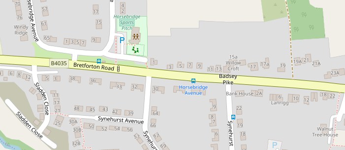
In Badsey you may hear someone say they are going Up the Pike or even Down the Pike. When they say that, they are talking about the top part of Synehurst, and the junction with the Bretforton Road. You might also see Badsey Pike mentioned on local bus timetables for the stop near the junction.
The name comes from Bretforton Road, which was an 18th Century Turnpike Road, and a 19th Century Tollgate which was built across it.
Turnpikes are toll roads which were created in great numbers across the whole country from the early 1700s through to the 1860s. Over one thousand Turnpike Trusts were set up to improve local roads, and sometimes to build new ones. The word Turnpike originates from a type of medieval defensive gate which had long poles with spikes. However, the gates that were used on 18th and 19th century roads were nothing like that.
From 1650 onwards, long-distance coach travel had started between the major cities in England, and heavy wagons were increasingly taking goods long distances as the population and economy grew. As it is today, the demand was for faster and cheaper travel. Before the turnpikes, roads were the responsibility of each Parish they travelled through, and some were better than others. Usually even the important roads were no different to today’s heavily rutted farm tracks, and the Parish repairs were often no more than tipping some stones into the deepest potholes. Before Turnpikes, four wheeled traffic typically averaged one mile per hour as a consequence, especially in winter.
Turnpike Trusts were non-profit making bodies managed by local trustees. The trusts borrowed money at attractive rates of interest – usually around 4% to 5% - to pay for construction of the roads and toll houses. Revenue from the tolls would eventually enable the loans to be repaid. Turnpikes Trusts were setup in large numbers from 1715 onwards, and by 1750 nearly all of the major roads in England were Turnpikes.
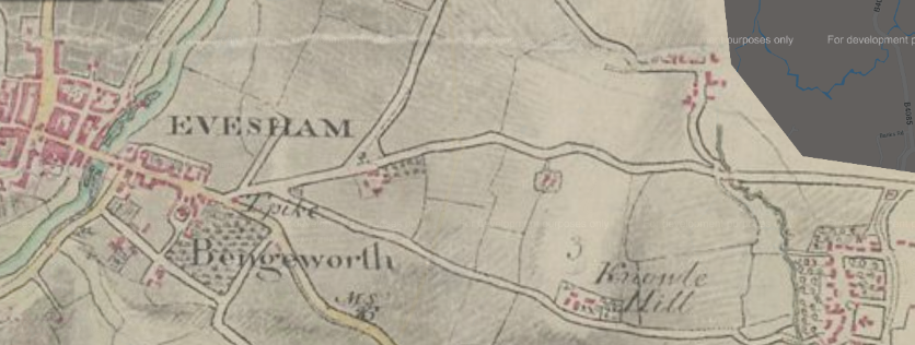
On 27th February 1728 Sir John Rushout, one of Evesham’s two MPs at the time, presented a Petition from the Town of Evesham to the House of Commons, proposing to build a Turnpike from the top of Broadway Hill (later called Fish Hill) through Wickhamford and Bengeworth and into the town of Evesham, before heading out towards Worcester on the north side of the river. In addition, several smaller roads were to be included including “to the gate in Offenham Lane leading to South Littleton”, and another road “to Bretfordton”.
These two small roads already existed as tracks, and joined at a place that used to be called Bengeworth Elm. They met the main turnpike road at the roundabout at the end of Elms Road near Lidl. The upgraded turnpike roads were to follow pretty well exactly the course of the two roads we know today - the B4510 Offenham Road and the B4035 Badsey/Bretforton Road.
A whole series of discussions took place in Parliament following letters from Pershore Town and from 30 villages all complaining about the motivations of Evesham Town for the route they had chosen. Pershore claimed, with some justification, that the road to Pershore through Childswickham and Hinton was the main road from Oxford to Worcester.
One Petition in March 1728 from 30 villages including Broadway, Bredfordton, Willersea, Badsey and others said that:
“The true intent of the inhabitants of Evesham …. is …. For rebuilding a large Stone Bridge over a deep and wide water within the said Town, a great Part whereof is lately fallen in, and must be entirely rebuilt … and ought to be repaired by the inhabitants of Evesham … ”
After much discussion a road from Bengeworth to Pershore was also included in the Turnpike Act.
The main aim of the turnpike was to create the local section of a good road from London to Worcester and onwards to mid Wales. That was achieved after the first Evesham Roads Act was finally approved by the Houses of Lords and Commons on Tuesday 14th May 1728.
So why were the roads from Bengeworth to Offenham and Badsey/Bretforton included when they were not on the new road to London? Why should local people pay the toll to take their horse or cart to Evesham or Pershore? If you believe the wording of the Evesham Roads Act:
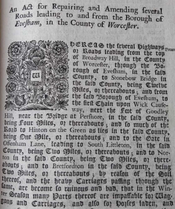
“… and to Bretfordton in the said County, being Two Miles or thereabouts; by reason of the Soil thereof, and the heavy Carriages passing through the same, are become to ruinous and bad, that in the Winter Season many Parts thereof are impassable for Wagons and Carriages, and also for horses laden, and other Parts are dangerous to Travellers;”
These were standard words used in most of the Turnpike Acts passed across the country during the 18th Century. In these more cynical times you might guess an additional motivation for the turnpike trustees. Any traffic arriving at Bengeworth Elm, from any direction, would have to pay the toll. There was no way to dodge the turnpike by taking a back road to one side and up the hills a different way. All of the roads were turnpiked so you may as well pay the few pence toll and take the main road through Wickhamford.
Therefore Badsey Pike was in some ways a road to nowhere – it just ran from Bengeworth to Bretforton. After that you were back on the inadequate parish-maintained roads to Honeybourne, Weston-sub-Edge and beyond. The trustees probably put some effort into improving the “new” road, and would have done that by taking broken stone from small nearby quarries. The road surface would have gradually improved, but stayed as loose stone until the 20th Century – Tarmac wasn’t even invented until 1902.
Traffic on Badsey Pike in 1728 would have been quite light, and it would have been difficult to justify the cost to build a tollhouse and to staff a 24 hour-a-day tollgate in Badsey. The tollgate at Bengeworth would have sold tickets for the Bretforton Road. The initial list of prices included One Penny for a Horse, Six Pence for a Cart, Wagon or Carriage with two horses, and Ten Pence for every twenty Pigs or Sheep. Return travel the same day before midnight was at no extra cost.
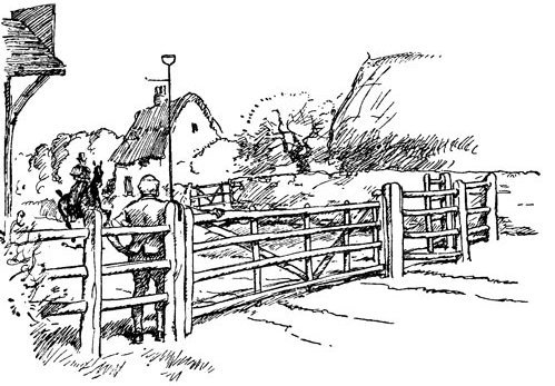
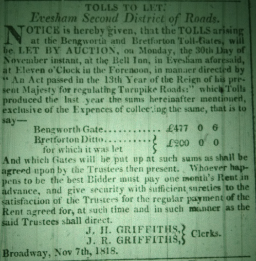
The Turnpike records available to us are very limited, but we know the tollgate on the busy section of the Turnpike in Broadway was not opened until November 1772. Bretforton certainly had a tollgate in 1818 although it’s not totally clear where that was situated. Badsey’s tollgate would come later.
Being a toll-keeper was a difficult and unpopular job, and open to theft and corruption. Turnpike Trusts found it most effective to give someone else the problem by letting the tolls to a contractor at the highest bid, and allowing the contractor to keep all the revenue.
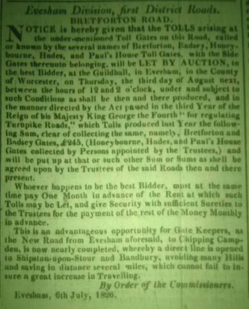
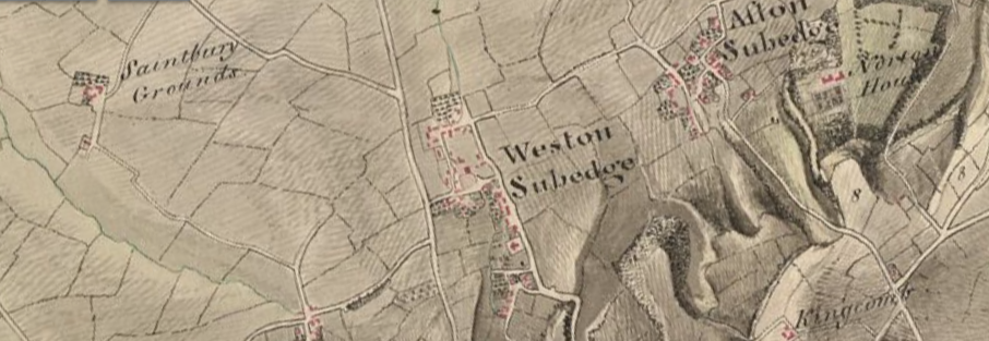
Turnpike Acts expired after 21 years, so the Evesham Roads Act was renewed several times, usually coinciding with some expansion in the road network. In 1822 a new Act of Parliament extended the Bretforton Turnpike to Weston-sub-Edge, left to Aston Subedge and on to Chipping Campden. A new tollgate was constructed at a place called Paul’s Pike halfway up the hill to Campden. The cottage and name sign are still there. Closer to Badsey a new tollgate was setup in a place then called Honeybourne Hades. It was at the small crossroads at the far end of Bretforton.
Badsey’s tollgate was certainly in place by July 1826 at which time the Turnpike Trust advertised in the Worcester Journal for bids to run the tollhouse for the next 12 months. In the announcement of the auction for the collection of tolls, the trust commissioners mention that "the New Road from Evesham … to Chipping Campden, is now nearly completed".
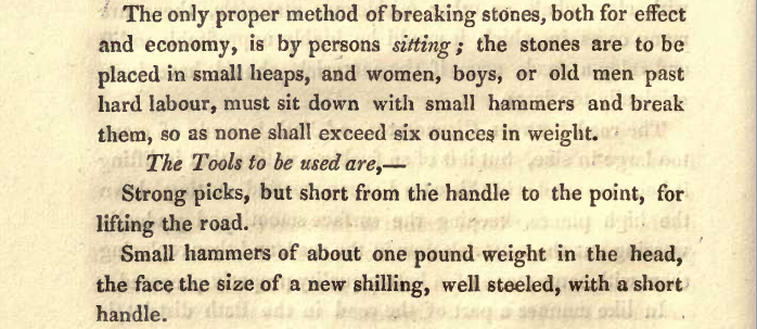
By 1826 the road would have been Macadamised, a new system of road building introduced by John Loudon McAdam. The top surface of the road would have been stones of no more than one inch in diameter. These were broken at the roadside with special hammers, sometimes by the parish poor - local women with their children.
4th Edition 1821
It’s easy to see it would have taken several years to complete the whole road to the new system, especially as some parts of the road were completely new.
We have records of a Turnpike Cottage on Badsey Pike from the 1851 census, but not before that. It is quite possible the gate was operated from a hut for the first few years. Maybe we will find some extra information about that sometime in the future. In 1851 Ann Attwood, listed as a gloveress, lived at the cottage with her children Edith, Job and Mary. In 1861 Ann was still there with Mary and her husband Thomas, a labourer. Ann is listed as a Gloveress and Toll Collector, so she was combining jobs. In 1871 the Tollgate Keeper was Ann Freeman who lived there with her husband Nathan and two children. That would have been in the last days of the turnpike. We know the cottage was demolished in the 1880s.
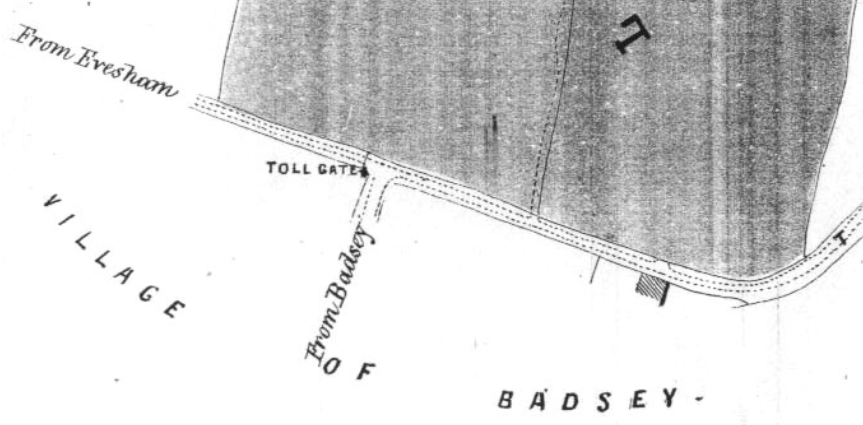
Fortunately, the Badsey Society has a map which tells us exactly where the tollgate was. A land sale in July 1866 provides us with a very detailed map of the village. The tollgate was right at the junction between Badsey Road and Synehurst, on the Evesham side.
The turnpike system started to collapse as soon as railways arrived. Stage coaches to London literally stopped on the day the local railways opened. Long distance freight traffic dropped in the Evesham area as soon as Defford Station – just beyond Pershore - opened in 1841. John Jolly was one of the largest carriers operating wagon freight services on a timetable from Worcester to London and across the West Midlands. He immediately took his long-distance wagons off Evesham’s roads when the railway stations opened. Evesham Station initially opened in May 1852, with the line to Oxford being completed in June 1853. That would have taken much of the traffic from the roads, and revenue from the turnpikes.
Despite revenue dropping by more than 50%, the turnpikes continued into the late 1860s or maybe early 1870s, at which point they were taken into local authority control and renamed Main Roads. Bengeworth’s Tollhouse was to be sold in 1876. So Badsey’s Tollgate lasted for less than fifty years, but the road itself lives on.
So why do we still call the junction Badsey Pike? It is not a name which appears on the enclosure maps of Aldington or Badsey, or on old or new Ordnance survey maps. It wasn’t even an official name for the road in 1728. However, the phrase “Up the Pike” has been preserved by many generations in the village, as well as local bus companies in their timetables. The late Richard Phillips of the Badsey Society did his bit by adding the name to the Open Street Map. Word of mouth over the space of nearly 300 years is a powerful thing.
David Ella, March 2020
See also:
- Aldington Toll House
- The Turnpike Road through Wickhamford
- The Way to London - Vale of Evesham Roads, 1350-1880