
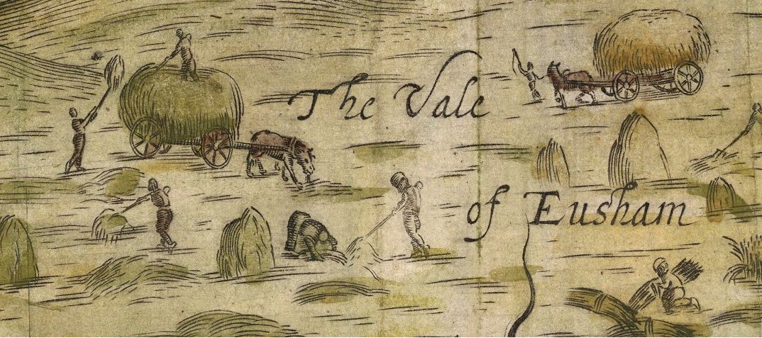
The Vale of Evesham has an extensive network of roads, tracks and paths. Some may be up to four thousand years old. Many of these tracks and roads were not deliberately planned and built – they came about through the continual passage of people, vehicles and animals. They essentially made and maintained themselves. This article looks at some of the old routes across the Vale of Evesham, and the turnpike roads which eventually replaced them in the 18th century. We will also look at the reasons – and inter-town rivalry - behind their introduction, construction and operation.
A long-distance traveller in the Vale of Evesham had to choose a place to cross the River Avon and decide on a suitable route to climb the Cotswold escarpment. Crossing points on the River Avon were slightly different to today, due to the removal or addition of bridges. Until the late 17th century the Avon was much shallower in summer, as there were no locks and weirs, enabling a number of fords at places such as Offenham, Fladbury and Cropthorne.
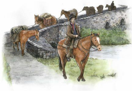
Most long-distance journeys were on horseback until the end of the 17th century. Queen Elizabeth 1st travelled side-saddle around England in the 1570s, and Oliver Cromwell caused comment by travelling by coach to Bristol in 1649. Farmers would use carts and wagons around the farm and to take goods to market, but for longer journeys movement of wheeled vehicles was restricted by the state of the roads. In some parts of the country more distant from London, for example from Liverpool to Manchester, goods were still being carried by long lines of pack-horses as late as 1750. For most of England the transport system was to change during the in the early 1700s through the introduction of a new system of turnpike roads.
We assume that travellers would choose to pass through all the towns along their journey, but this wasn’t necessarily the case. As the Romans had understood over a thousand years earlier, travellers on long-distance journeys wanted to take the fastest route practically possible on the roads and tracks that were available. Fast routes would minimise the mileage, avoid unnecessary hills and valleys, and avoid delays. Passing through towns and villages could take you off the fastest route and waste time, especially for packhorses. Lead packhorses on regular journeys often knew the route ahead if there were no complex junctions or people around to distract them. A high average speed meant you could easily save a day on a journey to London. An experienced walker would cover perhaps 25 or 30 miles daily. Horses - including packhorses which would carry a load of around 100 kilos - could go a little further but would not be fit to travel the next day. For a cart or wagon, 10 to 15 miles a day was a practical limit, depending on the roads and terrain.
Ancient Roads across the Vale
Up to the late 17th Century, the busiest road from London to Worcester did not run through the town of Evesham. This road ran from Moreton-in-Marsh to Broadway, where it forked left to run through Childswickham, Hinton Cross, Little Comberton and Pershore. The first roadmaps of England and Wales - probably the world’s first road atlas - were published by John Ogilby in 1675. The first route in Ogilby’s atlas – from London to Aberistwith - followed this road. As we will see later, Pershore was quite insistent that this was the ancient route to London.
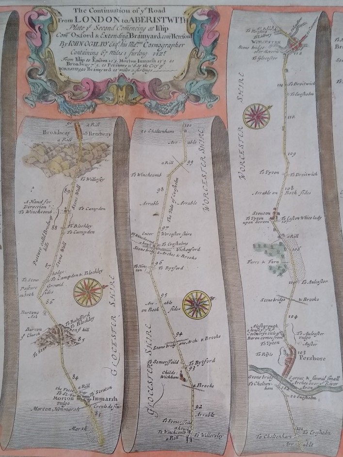
Another, and perhaps much earlier, road between London and Worcester took a different route, this time north of the River Avon. We know from Anglo Saxon charters that this was a Saltway, on which packhorses carried some of the 1000 tons a year of salt produced in Droitwich since pre-Roman times. The complete (and straight) journey from London was through Uxbridge and High Wycombe, Wheatley, Islip, Chapel House, and to the north of Chipping Norton near the Rollright stones. The road then joined the current A44 for the short section between Kitebrook and the Four Shires Stone (near the Fire Service College), before taking a fairly level line through Dorn, Broad Campden and Chipping Campden. It then descended the Cotswold escarpment – probably for most travellers along Buckle Street - before entering the Vale of Evesham. In the Vale the road went to Bretforton and then direct to Offenham where it crossed the River Avon using the old Twyford bridge or ford. These were sited at the current Bridge Inn in Offenham. Once across the river, the road took what we now call Blayneys Lane to the top of Greenhill, and then down The Squires to re-join the current A44 route to Spetchley & Worcester.
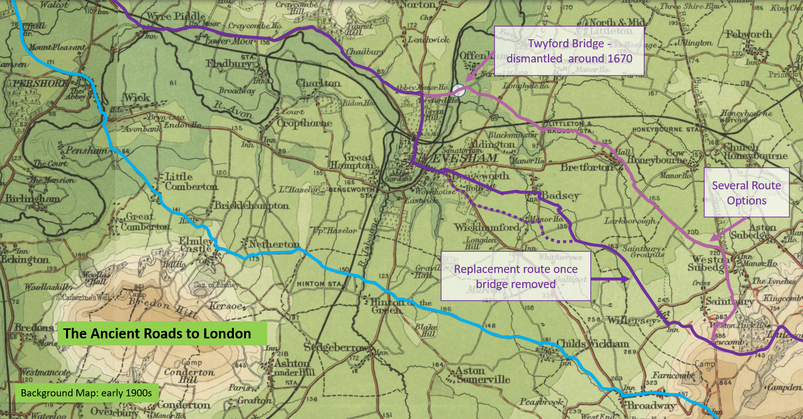
In the 1660s or 1670s Twyford Bridge – which was a narrow packhorse bridge - either fell down through lack of repair by Offenham Parish, or was taken down as it was too low for boats. In 1636 William Sandys, who owned family property in Fladbury, spent most of his personal fortune of £40,000 on a project to make the Avon navigable for boats as high as Stratford and Warwick. This involved dredging, weirs and basic flash locks. These were simple sluices that were removed when boats needed to pass. The last of these – the Pershore Watergate – remained until the 1960s. Sandys improved the river but it wasn’t until after the English Civil War that the project was completed by others, in the 1680s. We know Twyford Bridge was in use during the English Civil War but it is unclear if this was one of the bridges damaged by the royalist army, despite this being recorded by the Victoria County History.
The ford alongside the bridge in Offenham continued in use until the late 1700s for farm wagons. This was reported by George May writing in 1834. The river level at that time was still as much as six feet (1.8m) lower in the drier season due to the inadequate system of locks in use along the Avon. In the summer it would have been possible to wade across the river in Offenham, where the river is now around 6.5 feet (2m) deep.
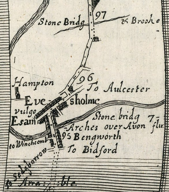
Once Twyford Bridge was gone, the road from Chipping Campden diverted down the hill to Willersey, and then took the current Willersey Road to somewhere between Wickhamford and Badsey and into Bengeworth. The exact route near Badsey is lost, and the roads have changed their position. After crossing the town bridge into Evesham, the road took what is now Briar Close and the road alongside the river past the current large Tesco store. This revised route also features in Ogilby’s 1675 road atlas Britannia as part of a different road, this time from London to Montgomery.
Before the 18th century, local roads were the responsibility of the parishes through which they passed. A 1555 Act of Parliament had set out specific details of parish statute labour which was to be used to maintain the roads. The system was unfair for small parishes with long busy roads running through them, and the result was roads that were poor and often completely impassable in winter. We have many examples of the Worcester Quarter Sessions starting to get tough on parishes in the mid-17th Century. The parish labour system was to continue into the early 19th century and was used to maintain the turnpike roads. The later turnpike commissioners were so unhappy that the villages of Murcot and Wickhamford did not provide labour to repair the turnpike road that they had the requirement written into the next Act of Parliament in 1743.
A good way to imagine the state of roads in the pre-turnpike era is as similar to a current farm track, with a surface of dirt and stones. At times they could be good, but when wet or in winter they could be treacherous or even impassable, especially for wheeled vehicles. If there was a hole or rut the parish would use a cart to tip in stones of various sizes from a local roadside quarry.
After 1650, scheduled passenger coaches were starting to travel around parts of England outside the major cities. The population was growing fast. These were the early days of the industrial revolution. Roads were a necessity to move raw materials, goods, and people. In 1674, on one of first recorded coach journeys from Worcester to London, a Quaker prisoner called George Fry, with the escorting Sheriff, set out on 4th December and arrived in London 4 days later on 8th December. Wagons started to transport goods in place of packhorses. As roads improved, people wanted to travel further and faster with heavier loads, and so the road surfaces suffered. These were all factors leading to the development of the turnpike system. By the mid-1830s over 20,000 miles of road would be “Turnpiked” under the control of over 1,000 Turnpike Trusts.
Evesham’s 1728 Turnpike Roads
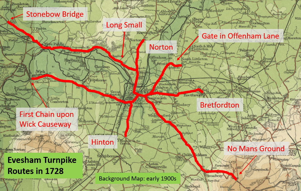
In the 1670s a toll system was devised for a section of the Great North Road through Hertfordshire. The local parishes had been unable to cope with the maintenance of this busy road and the tolls were introduced so the users would pay for the upkeep of the road. This was called a Turnpike road. Turnpikes didn’t start to be adopted in any great numbers elsewhere in the country until after 1710. In the mid-1720s towns in the west of England started a trend for town-centred Turnpike Trusts, which would look after all major routes through or near a town rather than just a single road. Worcester, Tewkesbury and Ledbury were just ahead of Evesham, where the first 1727 Evesham Roads Act was passed in 1728. By 1750 only small sections of the 13 major roads radiating from London had not been taken over by a Turnpike Trust. The section from the top of Broadway Hill to Bourton-on-the-Hill was one of the last and, as we will see, this would be taken over later by the Evesham Trust.
Evesham decided travellers should pass through the town rather than skirting it on the old roads. A route was chosen, and a Petition was presented to the House of Commons on 27th February 1728. It was referred the same day to a meeting of a committee which included Sir John Rushout and John Rudge, then Evesham’s two members of Parliament. Evesham chose a route direct from Broadway, on an existing but badly maintained road through Wickhamford, to Bengeworth, and then across Evesham Bridge into the town. Once in town the turnpike route turned north up Greenhill before turning left onto The Squires, opposite Blayneys Lane.
Pershore quickly became quite upset by Evesham’s proposal, saying that their own route through Childswickham and Hinton was the great road to London. Their view was that travellers would still want to pass south of the River Avon through Pershore on the existing road, and that these travellers would be disadvantaged as they would have to pay the full toll, but would only use the new road for the last part through Broadway village and up Broadway Hill. Pershore published a pamphlet and immediately submitted a petition to the House of Commons stating their point of view.
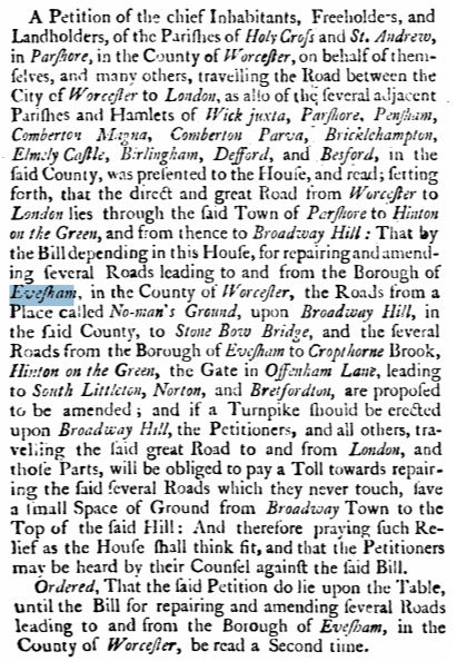
A compromise solution was suggested to Parliament on 26th March 1728 by Pershore and some nearby villages, improving an existing road along the riverside from the Bengeworth side of the Evesham town bridge, to Hampton and along the current route to a short distance before Pershore Bridge. The road towards Worcester to the north of the River was regarded by the Evesham townspeople as the major road to Worcester and it of course had the advantage that travellers passed Evesham’s Shops, Inns and Market. In April 1728, thirty surrounding villages petitioned parliament to say that Evesham’s true motive in proposing this new road was to allow the turnpike revenues to pay for the repair of Evesham Bridge, which had “lately fallen in”.
The Evesham Roads Act was passed by both Houses of Parliament in May 1728, and over 150 named trustees were appointed, so the process seems to have been fast and efficient. The major part of the new turnpike road was to run from the top of Broadway Hill (which was not yet called Fish Hill), through Evesham as described, and north of the river to Stonebow Bridge, north of Pershore. This may seem a strange place to stop, but was where the Worcester turnpike road came to an end, following a 1725 Act of Parliament. In 1743, a new Act clarified that the roads met in the middle of the bridge, so any repair costs were to be shared between the two Turnpike Trusts.
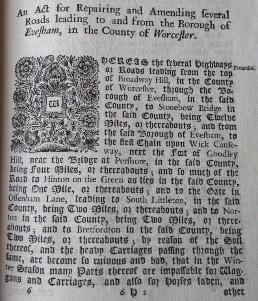
In addition to the Broadway Hill to Stonebow road, and the link to Pershore through Hampton, small spur roads were also included, to Bretforton, to South Littleton, to Norton and to Hinton. The spur roads were for the convenience of travellers and townspeople, but in some cases also had the effect of reducing the chances of travellers bypassing some or all of the turnpike and not paying tolls.
Toll Fees and Toll Gates
Tollgates were set across the road at strategic places to ensure most road users had to buy a ticket. These tollgates were not necessarily at the end of the road, and some of the short roads did not have their own tollbooth, at least until traffic increased. The most important toll-houses across the life of the Evesham Trust were at Hampton (at the junction which now includes Abbey Bridge which then did not exist), and in Bengeworth near the current roundabout on the way out of town. Other tollgates were added and moved at different times. Sometimes there was a tollhouse but there was sometimes a temporary hut or booth. Later additions to the Evesham roads were often separate trusts for legal reasons, including the split ownership of the road with other towns, and as the road network expanded (as explained below) the whole Evesham trust was split into three self-accounting divisions. Local people seemed very interested in their own stretch of road through their Parish, and while that was probably a good thing, it was heavily criticised in the early 19th Century when there were calls for more professionalism in the road engineering, less tollhouses and trusts, and consequently lower administration costs and cheaper and simpler travel.
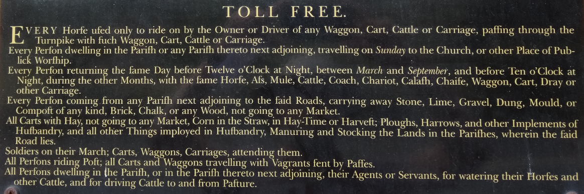
The fees to be charged to different categories of road users were set out in the 1728 Act of Parliament. Tickets were sold at the tollgates and allowed a free same day return. The Pershore Tollhouse, which remains at the edge of the town, still displays a price list for the road towards Evesham. Pedestrians were not charged, and a penny for a ticket for horse and rider was common on many turnpikes. There were various exceptions which allowed some free travel, involving for example some travel on Sundays, and some Farm traffic, to ensure charges weren’t entirely unreasonable. Over the life of the turnpike road system the costs for transporting heavy goods reduced in real terms, as the volume of traffic and the weight of each vehicle increased.
To avoid traffic hopping onto and off the turnpikes to avoid tollhouses, the turnpikes were allowed to create side-bars – blocking off certain side roads with barriers or chains. However obviously normal traffic was allowed to cross a turnpike. In some parts of the west of England, including Tewkesbury, there were some protests about the turnpikes from a minority which could not see a benefit to them, but this is not recorded having been an issue in the Vale of Evesham.
|
Coach or Chaise with 6 or more horses |
1 Shilling 6 Pence |
|
Coach or Chaise with 4 horses |
1 Shilling |
|
Coach or Chaise with 1 or 2 horses |
6 Pence |
|
Wagon, Cart, or Carriage for hire |
1 Shilling 6 Pence |
|
Wagon or Cart with 3 or more horses or 4 or more oxen |
1 Shilling |
|
Wagon or Cart with 3 horses or 2 oxen |
6 Pence |
|
Mule or Horse |
1 Peny |
|
Oxen, Cows & Cattle (per 20) |
1 Shilling 3 Pence |
|
Halves, Hogs & Sheep (per 20) |
10 Pence |
Extract from the 1728 Evesham Turnpike Price List
The price lists showed pricing for animals being taken to market or across the country by Drovers. The Vale of Evesham wasn’t one of the preferred routes for drovers from Wales taking livestock to market in London, and drovers would often keep off turnpikes to avoid the fees, but drovers and farmers would sometimes use the turnpikes to take livestock to market.
Turnpike Trusts borrowed money from wealthy local people to construct and operate the roads. Debentures were raised which promised to eventually repay the loan from receipt of the tolls, and to pay annual interest – usually or between 4% and 5% - from tolls received from road users. The total amount of money borrowed was affected by the work required to construct the road, but could typically be in the order of £1,500 to £5,000, with individuals typically investing sums between £100 and £500.
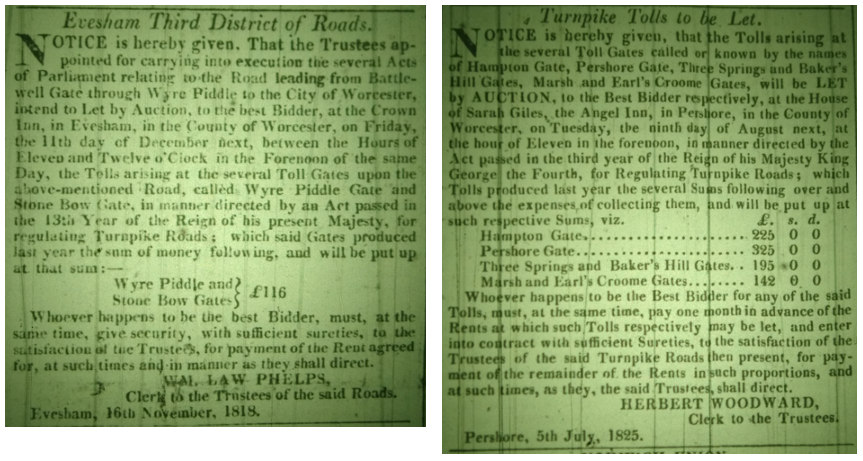
Toll-keepers – described as “They're all on 'em men as has met vith some disappointment in life” by Charles Dickens in Pickwick Papers – were responsible for collecting the tolls, but there was an opportunity for theft and fraud. Like most turnpike trusts, Evesham eventually decided to let the tolls to a contractor. Based on knowledge of the previous year’s receipts the contractor would submit a tender, and the winner of the competition for the next year or three-year period would usually make payment to the trust on a monthly basis. This process encouraged the toll-keeper to maximise their ticket sales. Worcester and Evesham newspapers in the 18th and 19th centuries are full of advertisements from numerous turnpike trusts wanting to put their tolls out to tender.
Expanding the Evesham Turnpikes after 1743
Turnpike Acts lasted 21 years, after which they were renewed with a new Act, often using the opportunity to add new turnpike roads at the same time. Sometimes those changes came sooner, and in 1743 the Evesham Act was changed to extend the turnpike over Pershore Bridge to the edge of the town, where the old toll house and price list still exist today. Lawyers were involved in every renewal and they seem to have justified their fees – often more than 30% of the cost of constructing the new or improved road - by going over the top with justification of the renewed turnpike act to ensure it was not turned down by Parliament. In 1742 the town of Pershore asked for the turnpike to be extended to the edge of the town - the Mill Tail, the site of the current Tollhouse. The original road had held short of Pershore bridge to allow traffic to take the old road up Goodleigh Hill without a fee. On 4th February 1742 it was reported to the House of Commons, from a parliamentary committee, that road users were evading fees by taking the common meadow towards Wick before re-joining the turnpike. Various witnesses from the town were brought to the committee to explain that the causeway from the town to the bridge was too low and needed raising for the winter months. A Mr Samuel Rickards had reported in front of the committee that:
“… it is very difficult, and many times impossible for Persons to pass on Horseback …. the Floods often continue for a Fortnight or Three Weeks together, when passengers are obliged to Ferry over the River, which is expensive to them”
By moving the start of the turnpike into the town and using turnpike funds to raise the causeway they achieved their objectives. Within the same parliamentary report in 1742 it was stated that the current revenue from the 23 miles of Evesham turnpikes was an average £400 per year.
In 1757 a major expansion of the turnpike road system took place under the control of the Evesham Trustees. The turnpike was extended from the top of Broadway Hill (at the “sign of The Fish” – The first time that name was used) to Bourton on the Hill and Stow-on-the-Wold using the familiar A44 and A424 roads we use today. To the north of Evesham the road was extended from Norton to Crabbs Cross (which is now as a suburb of Redditch). Beyond Pershore, roads to Defford and Upton-on-Severn were added, still as part of the Evesham trust.
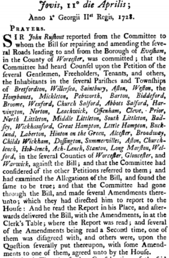
Also in 1757, the Act included a road from “the lower end of Wickhamford” to Willersey, up Willersey Hill and to the edge of Chipping Campden near Dyers Lane. This road was added against the Evesham’s trustees wishes, since they had reported in Parliament on 3rd May 1757 that only one village would benefit and costs would be thousands of pounds and would be only a mile from the existing road to the top of Broadway Hill. The road made it into the new Act but with the condition that it would only be constructed once all other debts had been repaid. The trustees had no intention of clearing all the existing loans and there is no evidence – such as no milestones – that the road was upgraded to a turnpike. This subject had also been raised in parliament at the time of the previous Act in 1742 with the justification that the road from Wickhamford to Willersey had been damaged by vehicles taking materials to the existing turnpike road through Wickhamford.
The first petition to Parliament for this new act was on 12th February 1757, and Royal Assent was on 28th June 1757 having gone through all of the stages of readings, and committees, and approval by the House of Lords as happens today. They were an efficient legislative machine.
In 1778 there was a change to the road north out of Evesham. Instead of turning left to Crabbs Cross (at the crossroad near the large current Hillers Farm Shop) the turnpike continued straight on past Ragley Hall, to Alcester.
We are told by George May in his excellent History of Evesham, first published in 1834, that the old route from Evesham to Tewkesbury was a road over Bredon Hill. We have already seen that travellers liked short and direct routes, but it is very likely that the slightly longer route across the shoulder of the hill taking in Aston-under-Hill, Grafton and Overbury would have been faster and less difficult. In any case this was to change in 1789 when an Act of Parliament created a new turnpike road from Hinton Cross to Teddington Hands. This provided a road from Evesham towards Cheltenham and Tewkesbury. With the exception of the Sedgeberrow bypass this is essentially the A46 route we use today.
Tewkesbury had been slightly ahead of Evesham in the creation of turnpike roads, and this text from 1721 explains how bad roads around the town could be:
“Roads are so very bad in the Wintertime, that they are almost impassable, and enough to stifle Man and Horse; and that Waggons cannot travel through the said Roads in the Summer-time“
Unusually, the first trustees minute book for the 1789 Hampton to Teddington Hands road is preserved in The Hive at Worcester, and it is useful in explaining how the road was created and managed. Within two weeks of the Turnpike Act being passed, bi-monthly meetings of the trustees (or commissioners) had started, alternately in Evesham and Tewkesbury. The minute book that remains only records the Evesham meetings, and this is one of several indications that roads between towns were administered fairly separately by different groups of people at each end. This does make sense when you consider that a trotting horse would take over two hours to get to Tewkesbury for a trustee meeting, even on the new road. In the original 1728 Act, the road to Pershore was to be managed largely separately by Pershore based trustees.
One of the first actions of the trustees in 1789 was to appoint surveyors for the new road. They were Septimus Smith of Hinton-on-the-Green for the section to Sedgeberrow Bridge, and William Mott of Beckford for the rest of the road to Teddington Hands. Surveyor was really a courtesy title as the science of road-building was in its infancy. Prior knowledge of building local farm tracks is probably the extent of their initial expertise. The surveyor’s main role would have been in organising parish labour for road repairs, and arranging with local farmers to create small roadside quarries to distribute stone along their portion of road. Compensation payments to land owners for loss of land or damage are detailed in the minute book.
A group of wealthy gentlemen, mainly from the Bredon Hill villages, set up the Vale of Evesham Road Club in September 1792 to encourage improved road construction and maintenance. Their major activity does seem to have been as a gentlemen’s dining club. Their monthly three-and-a-half-hour lunch was held at different Inns around the Vale, including the Crown in Evesham. Lunch - including drink - cost five shillings at a time when daily farm labourers pay was one shilling. However, the club did have some valuable aims & achievements. One of them, astonishingly, was to encourage each village to display their name in a conspicuous place at the entry to the village.
It is fairly surprising that anyone was able to find their way at all in the days before turnpikes, because road signs were so rare that the 1675 Ogilby road map specifically shows “a cross hands for direction” on the road junction towards Chipping Campden beyond Broadway Hill. A duplicate of that old sign is still in place on the A44, and what is thought to be the original sign now hangs from the ceiling of the old Chipping Campden Court House. In 1794 another route from Evesham to Tewkesbury was provided when the road from Bredon to Beckford was made a turnpike by the Tewkesbury Turnpike Trust. Most impressive mileage pillars are in place in both of those villages, though it’s not clear whether they were originally built by the Vale of Evesham Road Club.
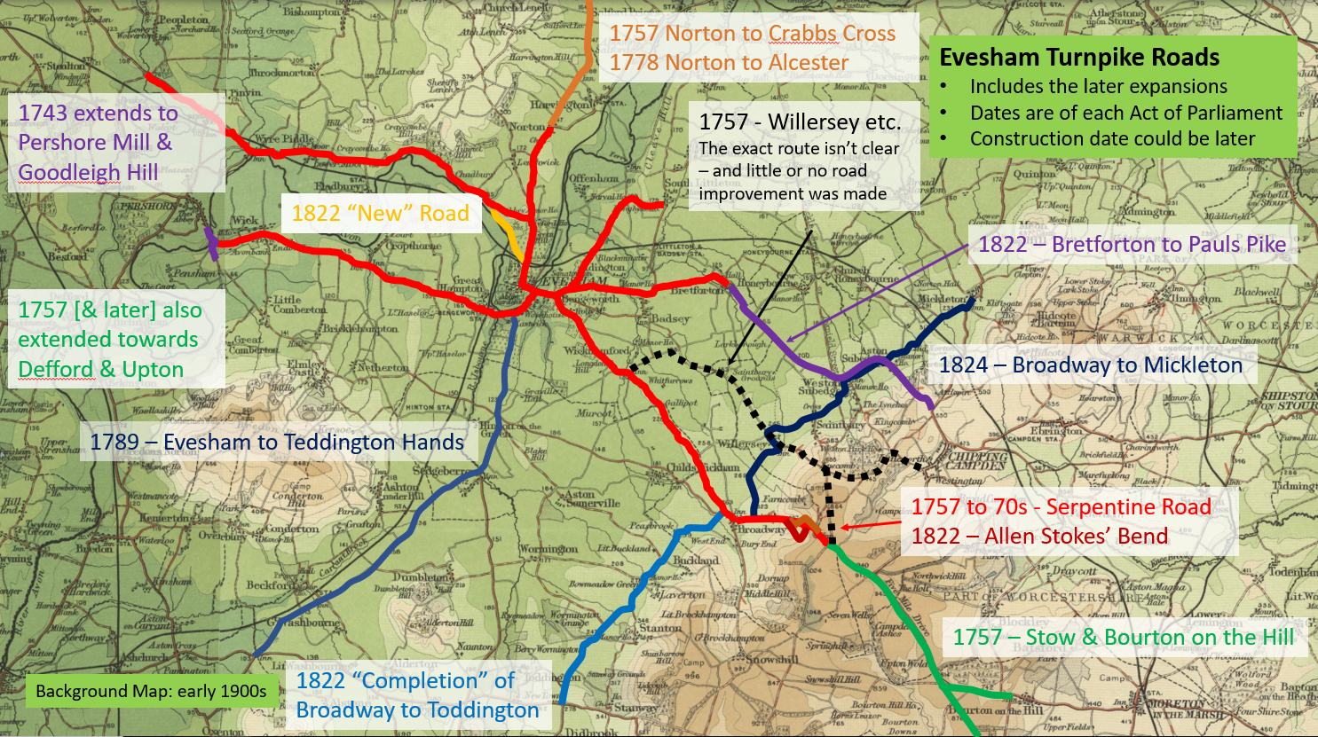
The last set of additions to the network of turnpike roads took place following the 1822 Evesham Roads Act. In the centre of Evesham, what was described as the “New Road” was created to avoid the need to go up Greenhill and down The Squires. This road ran alongside the river past the current large Tesco store to Chadbury. We have already seen that this same route was shown on the 1675 map so the road was not completely new at all. However, it probably changed from a muddy track to a decent broken stone road.
An important series of changes at the eastern side of the Vale were also included in the 1822 Act, along the Cotswold edge all of the way between Mickleton and Toddington. In Broadway this included the Leamington Road. Before that time, very surprisingly, there was no continuous road linking the villages at the Cotswold edge. Travellers could find their way through from village to village on individual tracks but sometimes travellers actually climbed and later descended the Cotswold escarpment to travel longer distances. Closest to Evesham these changes also involved an extension of the turnpike road which previously ran from Evesham, through Badsey to Bretforton. This road was extended to Weston-sub-Edge, left along the base of the hills to Aston-sub-Edge and part way up the hill to Chipping Campden, to a place recognisable today as Pauls Pike. Some of this new turnpike, including the stretch from Buckle Street into Weston-sub-Edge and the part through the village of Aston-sub-Edge, was completely new road and it was the late summer of 1826 before construction was complete.
New Routes on Broadway Hill
A challenge for long-distance travellers on the way to Oxford and London was always the ascent of the Cotswold edge. Whichever route was chosen, the climb was over 600 feet (200 metres) and it was invariably steep. For travellers on foot or horses this was not a problem, and the original routes that early travellers used were pretty direct up the hills. A steep hill was preferred to a longer journey. All of the possible routes from the Vale to the high Cotswold had a gradient of over ten per cent. Some of them had sections of 15% gradient. When heavy carts, wagons and coaches came into use the older steep routes became totally unsuitable. The optimal slope before lighter loads or more horses are required is 7% to 8%. Today’s Highways Agency standards aim for a maximum gradient of 6 per cent for new single carriageway roads but accept there will be exceptions in hilly terrain.
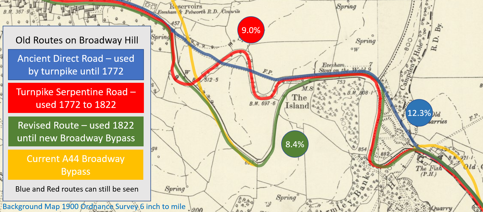
For traffic to the Vale of Evesham, Broadway Hill – called Fish Hill after 1755 – was selected by the turnpike trust, but initially the trustees just improved the old direct pathway, which had an average gradient of 12.3%. As an interim solution additional horses were available in Broadway to add pulling power. As turnpikes became more regulated, vehicles with more than four horses were strongly discouraged through extra tolls. Six horses were the maximum allowed for any vehicle but were rarely used. Earlier Turnpike Acts provided a provision whereby if hills had a gradient of more than “four Inches in a Yard, upon an average” (i.e. 11.1%) the local trustees could allow sufficient horses to be added to reach the top of the hill, between clear marker posts. One of those posts survives today in Broadway High Street. In July 1752 approval was given at the Worcester Quarter Sessions for up to ten horses to be used from the White Hart Inn (now the Lygon Arms) in Broadway until the top of Fish Hill.
The Evesham Trustees took their time, but eventually created a new route up Broadway Hill with a number of bends to reduce the gradient. This was described as the Serpentine Road and it was completed around November 1772, which is when a new tollhouse (which still remains in the High Street) was opened in Broadway village. The new road was an improvement, but was still really too steep, with an average gradient of 9.0% and bends which were too tight in the steeper sections. In 1821 prominent landowner Sir Thomas Phillipps offered some of his own land to create a new section of road down to the lower hairpin bend which we still use today. That new section opened in 1822 offering a gradient of 8.4%. Constructed under the supervision of expert professional surveyor John Allen Stokes, this involved the excavation by hand of 17,500 cubic yards of rock and soil – around 35,000 tons.
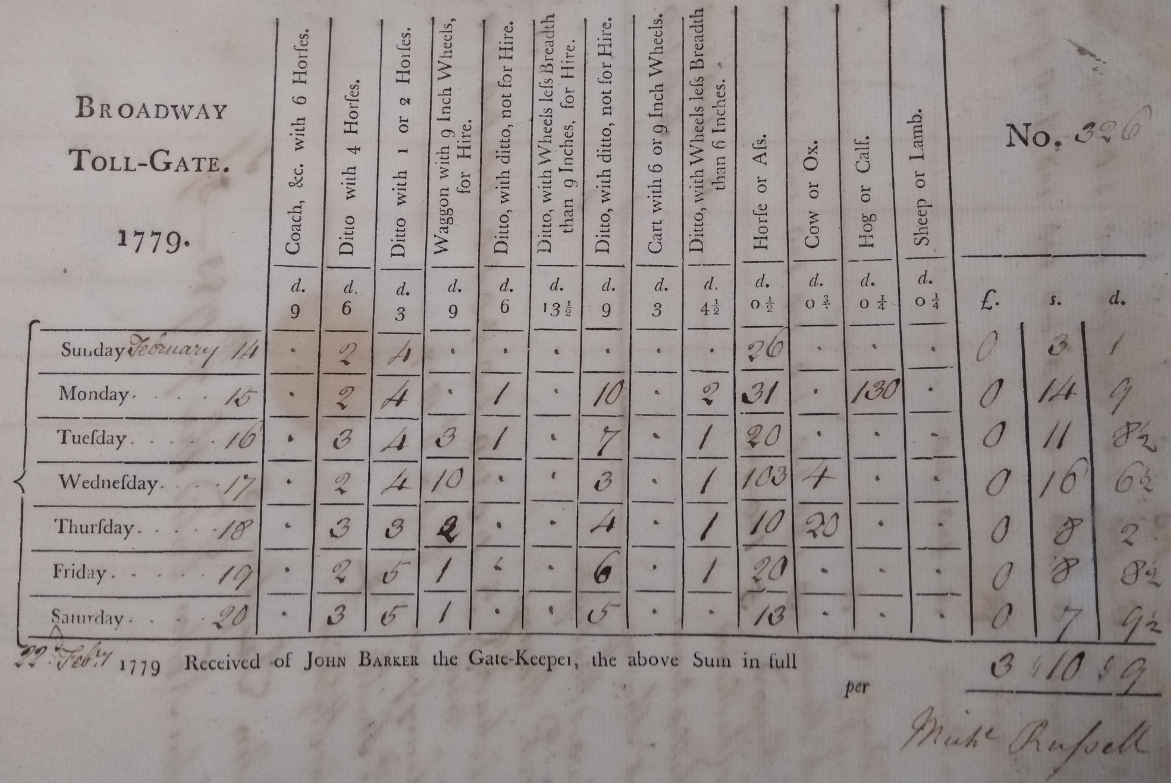
One of the few other historical records of the Evesham Turnpike Trust which has been preserved is a toll book from Broadway Toll House in 1779. This was found in the loft of a local house in 1907. The book gives us an analysis of the ticket buying traffic on a week by week basis for most of a year. We tend to assume that the turnpike would be fully occupied with carts, horses and coaches, much like the roads are today, but that was certainly not the case. You would only see a few travellers every hour as can be seen from the example below of weekly takings. The number of coaches is very low – only 46 in this whole week, and none of them with more than 4 horses. Actual traffic would be higher as this would exclude tickets bought at another gate.
Road Regulation and Maintenance
Like today, good roads generated more fast and heavy traffic, and without a sophisticated way of building stone roads the initial turnpikes in the Vale of Evesham and across the country deteriorated regularly. Maintenance was still usually through filling holes and tipping cart loads of broken stone along the centre of the road and allowing the traffic to spread it out to the edges. By 1789 the roads had improved to the extent that coach traffic was able to average seven miles an hour rather than the pre-turnpike walking pace. Twenty years later John Loudon McAdam was to introduce a system of roadmaking involving professional surveyors and roads constructed in a simple way with surface stones no more than one inch in diameter. He wrote many editions of his booklet System of Roadmaking and through evidence of his initial success in the Bristol area was able to persuade Parliament that his system would improve the roads and reduce maintenance costs by up to 50 per cent, and this proved to be correct. By the early 1820s, the start of the “golden age of coaching”, the road surfaces were better and in 1833 Evesham’s Surveyor, John Allen Stokes, reported to a parliamentary committee that Hirondelle, the fastest coach in the country, was able to travel from Cheltenham to Liverpool at a remarkable average speed of 10.5 miles per hour. This would have included the time required for horse changes at Inns every 8 to 10 miles. Roads improved by McAdam’s method were later described as MacAdamised but note this wasn’t Tarmac which wasn’t discovered/invented until 1903.
Information about the width of the turnpike roads is most easily obtained from the later parish Enclosure Acts. Quieter turnpike roads would be as small as eighteen feet wide, but busier roads as they went into villages would be sixty feet “between the ditches”.
Alongside all of the individual turnpike acts for Vale of Evesham roads, various additional Acts of Parliament in the 18th Century tightened rules and removed loopholes from the regulations. These were all later brought together in the 1822 General Turnpike Act. The toll-keeper’s life became more complex as prices varied according to wagon weight and the size of their wheels. Throughout the life of the turnpike system there had been particular concern about the width of wheels and the weight of wagons as these were seen to create the greatest damage to the turnpike road surfaces. The maximum weight of wagons had changed from one ton when the Evesham turnpikes were introduced, to six tons by the time of the final General Turnpike Act, at which time a 6 or even 9-inch-wide wheels for heavy wagons were compulsory. This new higher weight limit required the ability for wagons to be weighed, so a weighbridge was installed near the town hall in the centre of Evesham.
The Golden Age & Decline of Turnpikes
The 1820s to 1840s were the peak years for the turnpike road system, in the Vale of Evesham as elsewhere. Roads were improving fast to allow a traveller to easily reach London from Evesham in a day, if they had sufficient funds for a stage coach ticket. They could alternatively hire fresh horses along the way from Posting Inns. A mail coach to Worcester starting each night from the Bull & Mouth Inn in the City of London was scheduled to take 12 hours 20 minutes in 1837, running at an average 9.3 miles per hour. As recently as 1828 the same mail coach journey had taken 16 hours according to the widely used road book Cary’s Itinerary.
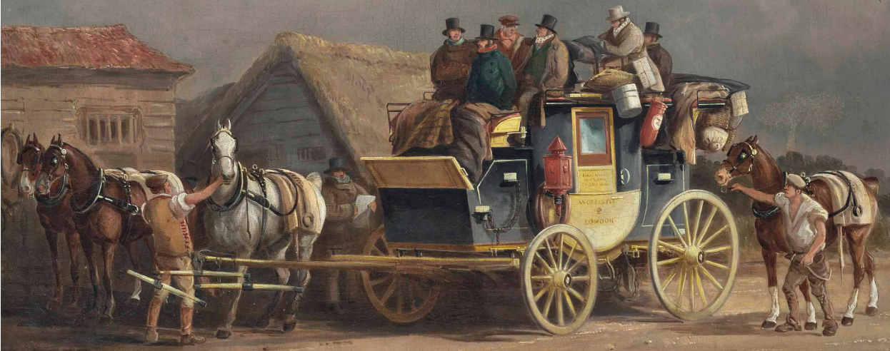
In this golden age of coaching, more goods were being carried longer distances at a lower cost per ton. Revenue had increased for the turnpikes. However, this quickly came to a crashing halt with the introduction of railways and the removal from the roads of the long-distance freight and passenger traffic. Long distance freight traffic dropped in the Evesham area as soon as Defford Station – just beyond Pershore - opened in 1841. John Jolly was one of the largest carriers operating wagon freight services on a timetable from Worcester to London and across the West Midlands. He immediately took his long-distance wagons off Worcestershire’s roads when the railway stations opened. Stage coaches to London literally stopped on the day the local railway stations opened. Evesham Station initially opened in May 1852, with the line to Oxford and London being opened later, on 4th June 1853, once the problematic Campden tunnel was complete.
The major difficulty for the turnpikes in Evesham and across the country caused by the arrival of railways was that the turnpike trustees had made little effort to repay the twenty-one-year loans which were taken out to build them, and which had been renewed every time there was a new Act of Parliament. As a consequence, they were in a financial mess when the revenue dropped by more than fifty per cent. Due to the level of debt, the local turnpikes staggered on until the Acts of Parliament were repealed in November 1875, but their responsibilities had at least in part been taken over by the Evesham Highway District, which was established on 19th October 1863 at the request of a group of local magistrates including Benjamin Workman. The Highways District was a short-lived body as responsibility was passed to the newly formed Worcestershire County Council in early 1889. During these changes Turnpikes were renamed to Main Roads.
One benefit to the local roads which did live on from the introduction of railways was that from the late 19th century strong surface stone for road repairs was brought to the Vale by train from Clee Hill in Shropshire.
In some parts of the country - as close as Oxford for example - the old turnpike roads have been replaced with completely new routes, and the old roads have faded away. In the Vale of Evesham, with the exception of some small bypasses and the straightening of some unnecessary bends, we are still able to use most of the old turnpike roads. We might decide to use a different route for the same journey, but, with a layer of tarmac on top of the original stones, the old turnpikes are there for us to use today.
+++
Information for this paper comes from the Worcestershire and Gloucestershire Record Offices, from the Shakespeare Birthplace Trust Archive, from the Bodleian Library Manuscripts Room, from the Pershore and Chipping Campden Archive Centres, and many on-line copies of books and maps. A VEHS booklet written by Ben Cox in 1980 comprehensively lists the turnpike routes, tollhouses and milestones. Evesham Inns & Signs by TJS Baylis & Stan Brotherton was also a useful reference. The best book about Turnpikes is The Turnpike Road System in England by William Albert 1972. Maps are from the author and the David Rumsey collection. Other information is from new on-the-ground road surveys and walks – including from Oxford to Worcester in four stages in 2019.
Copyright David Ella, November 2020 (first published in The Vale of Evesham Historical Society magazine, Almoner’s Pen)