
Two main routes took traffic from London and Oxford to Worcester until the early 18th Century. Both of them crossed the Vale of Evesham, but neither of them passed within a mile of the town of Evesham. In 1728 this was changed through the introduction of a new turnpike road which ran through Wickhamford. This eventually became the A44 which we know and use today.
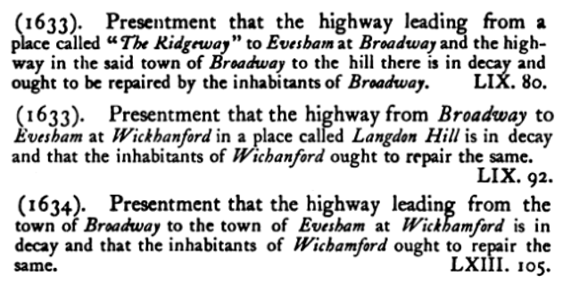
The current road through Wickhamford did exist as a track long before the turnpike road was established, but was seen as a poor option due to the condition of the track and the exposed position running along the top of a ridge. There are court records from Quarter Sessions in 1633 and 1634 showing that the road was not being adequately repaired by the local parishes.
In 1904, local travel writer Algernon Gissing wrote about the Wickhamford route in his book called "Broadway – A Village of Middle England":
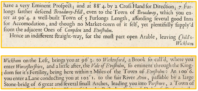
 In reading of …. the highway between Broadway and Evesham it must be remembered that the first part of it had not then the advantages of its present position. It did not, as now, keep to the top of the ridge by Whitechapel to the Sandys Arms at Wickhamford, but ran under the slope by the west side at the village of Childswickham and Murcott. … The old road makers would scarcely have chosen so exposed a line, and those who now ride or walk it in a south-west wind, as we say here, “straight from the Channel” will understand something of the merits of the lower line.
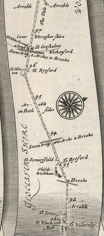
Gissing is talking about one of the two “ancient” routes, which ran through Bourton on the Hill and Broadway, as the A44 does now, but in Broadway village took a left fork to pass through Childswickham and onwards to Hinton on the Green, where it crossed the current A46 at a road junction called Hinton Cross. The road then passed Elmley Castle before joining the current Pershore Road just before Pershore Bridge. This road features as part of the first route in the world’s first road atlas which was published by John Ogilby in 1675 (pictured left).
John Ogilby’s 1675 atlas Britannia contained a page of description for each of his maps, which were presented as multiple strips on each page. The description of the section from Broadway to Pershore is shown below. In error a surveyor has recorded a stream near Hinton on the Green as Wickenford instead of the River Isbourne. The error caused confusion for the following generations of map makers for almost 100 years.
The second ancient route took what are today small roads to Chipping Campden from the Four Shires Stone. The stone – now actually a monument – is just to the east of the Fire Service College at Moreton in Marsh. Until around 1660 the Chipping Campden route descended the Cotswold escarpment to Bretforton, went forward to what is now Blackminster, and then on to Offenham Cross to reach the River Avon at Twyford bridge and a ford. The bridge was situated at the current Bridge and Ferry Inn. From the west bank of the River Avon the route took Blayney’s Lane and roads on the north side of the River Avon to Spetchley and then Worcester. This part of the route was also a historic Salt Way, used by packhorses since Roman times to distribute some of the thousand tons of salt produced each year in Droitwich.
Soon after 1660, Twyford bridge either collapsed or was taken down as part of a project to make the Avon navigable up to Stratford-on-Avon and beyond. When Twyford Bridge was gone the Broadway & Childswickham route gained greater favour. Another variant of the route from Chipping Campden and Willersey also appeared in the 1675 Ogilby atlas and will be the subject of a separate article because it passes through the bottom end of Badsey.
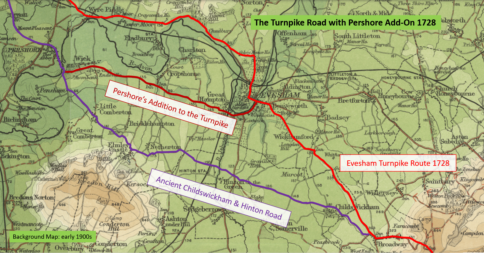
Early in 1728 Evesham decided it wanted travellers to pass through the town rather than skirting it on the old roads. The timing for this tied in nicely with the conversion of most of the important roads across England and Wales into Turnpikes. These were toll roads owned by non-profit making trusts. Over 100 landowners, the mayor, burgesses and other wealthy or worthy people from the town chose a route, and supported a bill presented to the House of Commons in February 1728. They chose the route direct from Broadway, through Wickhamford, along what is now Pitchers Hill, to Bengeworth, and then across Evesham Bridge into the town. Once in town the original turnpike route went north up Greenhill before turning left onto The Squires, opposite Blayney’s lane.
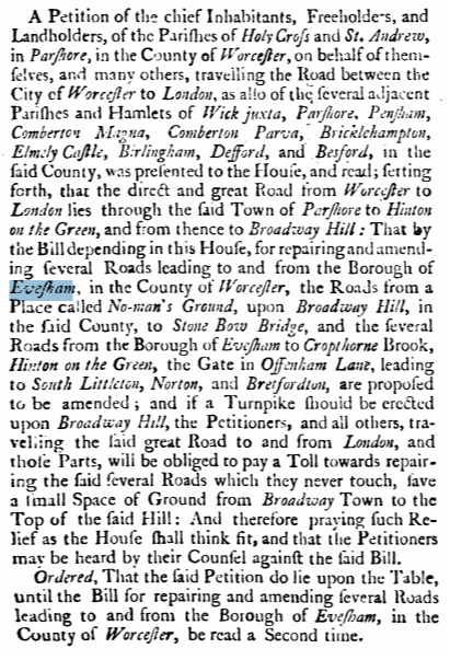
Pershore quickly became quite upset by Evesham’s proposal, saying that their route through Childswickham and Hinton was the great road to London. Their view was that travellers would still want to pass south of the River Avon through Pershore on the existing road, and that these travellers would be disadvantaged as they would have to pay the full toll, but would only use the new road for the last part through Broadway village and up Broadway Hill. They quickly presented a petition to the House of Commons explaining their point of view.
The conclusion - of what was a lengthy set of discussions in a Parliamentary committee - was that the existing road or track from the bridge at Bengeworth to Pershore would also be upgraded to a Turnpike. It transpired that Pershore was correct, and most of the traffic in the next hundred years or more followed the south of the River Avon through Pershore instead of the newly upgraded road to the north of the river.
The first Evesham Roads Act was finally passed – with amendments - by both Houses of Parliament in May 1728. It wouldn’t have taken long before the turnpike trust started taking road tolls, as the road through Wickhamford already existed - albeit with a poor road surface. Initially the tolls would have been taken through a tollgate in Bengeworth. We don’t have the minute book of the turnpike trust for the road through Wickhamford, but when the road from Hinton Cross south to Teddington Hands was turnpiked later in the 18th century the minute book shows that it only took a week between the passing of the act extending the turnpike to the appointment of surveyors and the implementation of tolls.
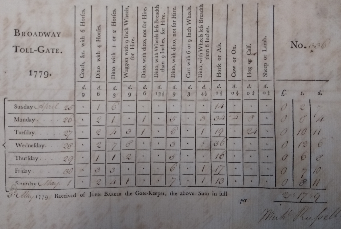
The new turnpike road would have been advantageous for the people of Wickhamford, except they would have been required to pay a toll if they were travelling on it with a horse, wagon or livestock. However, there was no tollhouse in Broadway until November 1772, so local traffic travelling in that direction could avoid payment. The tollhouse was a cottage which can still be seen in Broadway high street towards the hill end. From a rare 1779 toll record book used at the Broadway toll house we can get some idea of how little wheeled traffic would have passed through Wickhamford in the 18th Century. The figures are for tickets sold at Broadway in a whole year, and were calculated by historian EAB Barnard in 1907:
- 6 Horse Coaches: 15 (Nil each day)
- 4 Horse Coaches: 881 (2.5 a day)
- 1 or 2 Horse Coaches: 1,744 (5 a day)
- Stage Wagons: 710 (2 a day) – These were freight services
Actual totals through Wickhamford were probably up to four times higher than those shown, because around half of the traffic would have purchased a ticket in Bengeworth instead, and same day return traffic is excluded as the ticket covers a two-way journey.
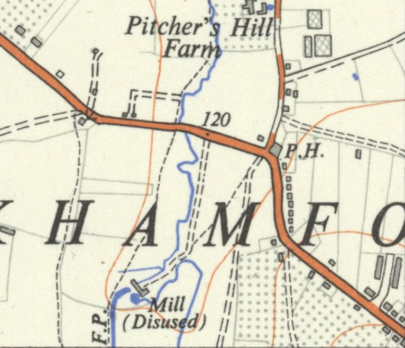
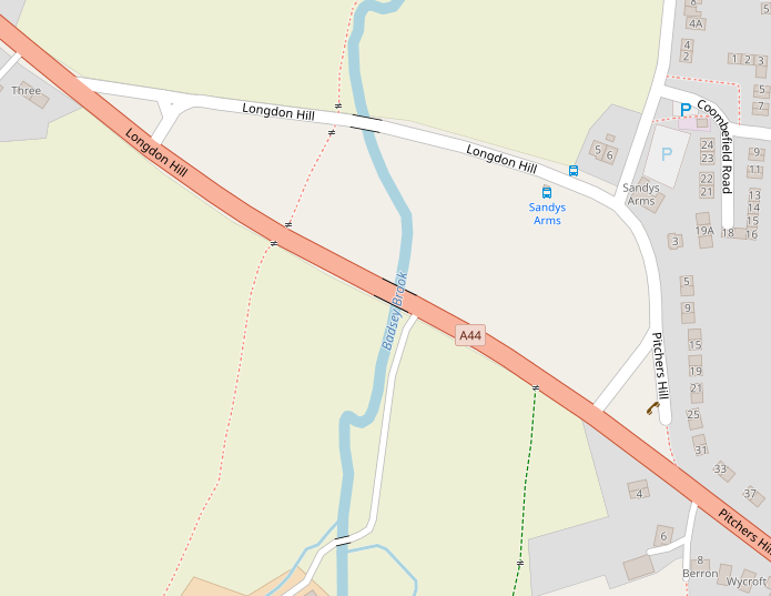
There were some differences in the position of the road in 1728 to what we know today. The most obvious change is that it wasn’t until 1958 that the road was straightened in Wickhamford. Until that time all of the traffic passed alongside what was from 1834 to 2012 The Sandys Arms public house. A few years later, in 1963, a small tunnel under the road was built to allow livestock into the otherwise cut-off field. The houses on both sides of the road at the Pitchers Hill junction with the A44 are angled to follow the old shape of the road.
The Badsey Society has published two articles with more information about Pitchers Hill, and another about the Sandys Arms. For further information about Turnpike roads in the area please also see the Badsey Pike and Aldington Tollhouse articles.
David Ella, May 2020